Hurricane in Florida: Updates and the Predicted Path of Hurricane Helene 2024
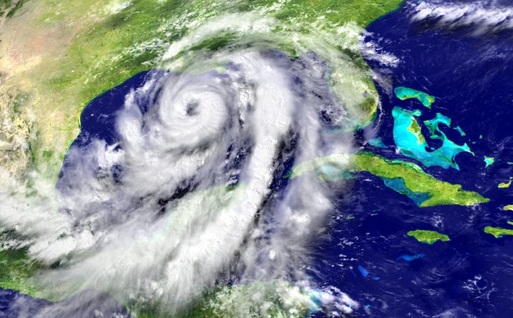
Hurricane in Florida remains a critical topic of concern as Hurricane Helene 2024 continues to pose a significant threat to the Gulf Coast and surrounding areas. Meteorologists are leveraging advanced satellite technology to monitor the storm’s trajectory, providing accurate and timely updates. These tools enable early warnings to local governments and residents, ensuring that emergency preparedness measures, evacuation plans, and resource deployments are implemented effectively. Such proactive efforts are crucial to minimizing potential loss of life and property damage caused by the hurricane.
The storm originated in the warm waters of the northwestern Caribbean Sea, an area known for fueling the growth of tropical storms. Since its formation, Hurricane Helene has gained significant strength, evolving into a powerful storm as it approaches the U.S. coast. As it moves closer to Florida, meteorologists are issuing regular updates to keep the public informed about its projected path, intensity, and impact.
In this article, we provide comprehensive updates on the Hurricane in Florida, including the latest projections, potential threats, and preparedness measures necessary to protect communities. From evacuation orders to safety tips, our guide ensures that you have the information you need to safeguard your family and property from this dangerous storm. Stay informed and ready as Hurricane Helene approaches the Gulf Coast.
What We Know About Hurricane Helene
Hurricane Helene 2024 emerged from the warm, storm-fueling waters of the Caribbean Sea, a region notorious for breeding powerful tropical storms. On Tuesday afternoon, the storm was recorded near Cancun, Mexico, with sustained winds of 45 mph. Since its initial observation, Hurricane Helene has rapidly gained strength, evolving into a significant weather threat as it moves north toward the United States.
Key Facts About Hurricane Helene 2024:
- Projected Strength: Meteorologists forecast that Hurricane Helene will intensify into a Category 3 hurricane, packing winds of up to 115 mph.
- Landfall Location: The storm is expected to make landfall along Florida’s Gulf Coast, with the area between Panama City and Cedar Key being the most likely target.
- Storm Surge and Rainfall: Florida’s Gulf Coast is preparing for storm surges between 5-10 feet and heavy rainfall, with some areas potentially receiving up to 12 inches.
Emergency warnings and tropical storm advisories have been issued for several counties along Florida’s coast, urging residents to take immediate precautions. In Mexico, authorities have activated emergency measures in Cabo Catoche and Tulum, highlighting the storm’s widespread impact across regions.
As Hurricane Helene approaches, timely updates from the National Hurricane Center (NHC) and local authorities will be critical in ensuring the safety of residents and the protection of property. Stay alert to weather changes and follow emergency instructions to mitigate the hurricane’s potential impact.
Current Path and Projections
As Hurricane in Florida continues its approach, the National Hurricane Center (NHC) has provided critical updates on the storm’s projected path and potential impact. This information is crucial for residents and local authorities to prepare for the challenges ahead.
Key Projections:
- Florida Panhandle Landfall: The storm is expected to intensify further before making landfall in the Florida Panhandle on Thursday night. Tallahassee lies directly in the storm’s projected trajectory, making it one of the areas at the highest risk.
- Evacuation Orders: Emergency evacuations have been issued for residents in Big Bend, Franklin, and Taylor counties to ensure their safety. These regions are bracing for storm surges, heavy rainfall, and strong winds.
- Path Beyond Florida: After making landfall, Hurricane in Florida is forecast to weaken as it moves inland into Alabama and Georgia. Despite weakening, it will still bring hazardous winds and torrential rains, leading to potential flooding and power outages.
- Midwest Impact: By the weekend, the storm’s remnants are expected to reach the Midwest, impacting areas along the Tennessee River with rain and stormy conditions.
Meteorologists are using advanced tracking tools, including satellite imagery and predictive models, to closely monitor the storm’s progression. These technologies allow for precise updates on its path, intensity, and timing. Residents are urged to stay tuned to regular hurricane updates provided by the NHC and local authorities to remain informed and prepared.
As Hurricane Helene 2024 approaches, prompt action and adherence to evacuation orders are vital. Staying informed and prepared will ensure that individuals and communities can mitigate the risks associated with this powerful storm.
Impact on Affected Regions
The devastating potential of Hurricane Helene 2024 lies not just in its wind speed but also in its far-reaching effects on the environment, infrastructure, and daily lives of residents in its path.
Storm Surges
Storm surges remain one of the most dangerous aspects of Hurricane in Florida. Panama City and Tampa are forecast to face surges of 10-15 feet, capable of inundating homes, roads, and low-lying areas. The Florida Keys, while less impacted, are still predicted to experience 1-3 feet of flooding, disrupting transportation and daily activities. Storm surges of this magnitude can cause severe coastal erosion and destroy critical infrastructure such as bridges, ports, and levees.
Rainfall and Flooding
Heavy rainfall accompanying the hurricane will exacerbate flooding concerns. The Florida coast could see up to 12 inches of rain, with Tallahassee expecting around 8 inches. Meanwhile, Alabama and Southern Georgia are forecast to experience 4-6 inches, causing localized flooding in rivers, streets, and residential areas. This level of rainfall can overwhelm drainage systems, flood homes, and render roads impassable, further complicating rescue and relief efforts.
Power Outages and Infrastructure Damage
Widespread power outages are expected as strong winds topple power lines and damage substations. Disruptions in transportation and communication systems will likely follow, complicating emergency response efforts and delaying recovery. Residents in impacted areas may face days or weeks without essential utilities, further highlighting the importance of emergency preparedness.
Impact on Ecosystems
The hurricane will have long-term consequences on ecosystems. Coastal wildlife, including seabirds and marine animals, may be displaced or stranded due to flooding and high winds. Additionally, saltwater intrusion caused by storm surges could harm vegetation and freshwater sources, disrupting local ecosystems.
Response Measures
Florida state authorities have already issued evacuation orders for 13 counties, prioritizing the safety of residents in high-risk areas. Emergency response teams, including power restoration crews, have been deployed to assist in minimizing the hurricane’s impact. Essential supplies such as food, water, and medical aid have been arranged to support affected communities.
As Hurricane Helene 2024 nears, proactive planning and timely responses remain crucial in mitigating its devastating effects. Residents are urged to follow evacuation orders and stay updated with hurricane news to ensure their safety.
Preparedness Measures for Hurricane Helene
Taking proactive steps before the arrival of Hurricane in Florida can make a significant difference in protecting lives and minimizing property damage. With Hurricane Helene 2024 projected to bring strong winds, storm surges, and heavy rainfall, preparedness is critical for residents in its path.
Stay Informed
Staying informed about the hurricane’s progression is one of the most crucial steps. Regularly check weather updates and advisories from trusted sources like NOAA and the National Hurricane Center (NHC). These updates provide real-time information about the storm’s intensity, path, and timing. Sign up for local emergency alerts and follow instructions from local authorities. Ignoring evacuation orders or warnings can put you and your family at unnecessary risk.
Create an Emergency Kit
Assemble an emergency kit well in advance to ensure you have everything you need if you’re required to evacuate or shelter in place. Include:
- Non-perishable food and bottled water for at least three days.
- Flashlights, batteries, and portable chargers for electronic devices.
- A fully stocked first-aid kit and necessary medications.
- Important documents such as IDs, insurance policies, and emergency contacts stored in a waterproof container.
Consider additional items like pet supplies, baby essentials, and extra cash to meet specific family needs.
Evacuate if Necessary
If local authorities issue evacuation orders, leave immediately. Delaying evacuation can put you in harm’s way as roads may become impassable due to flooding or debris. Familiarize yourself with designated evacuation routes and shelters in your area. Make sure your vehicle has a full tank of gas and keep essential supplies ready for travel.
Seek Shelter
For those unable to evacuate, move to a safe area within your home. Designated storm shelters are the safest option, but if unavailable, choose an interior room on the highest level of your building. Avoid closed attics, as rising floodwaters could trap you. Always have a plan to contact emergency services if your situation becomes life-threatening.
Avoid Dangerous Areas
Floodwaters are one of the most hazardous elements during a hurricane. Never attempt to swim or drive through flooded areas, as they may hide sharp objects, downed power lines, or strong currents that can sweep vehicles away. Always prioritize safety over convenience when navigating storm-affected areas.
By following these preparedness measures, residents can reduce the risks associated with Hurricane Helene 2024 and protect themselves and their families during this challenging time. Stay vigilant, take precautions, and act swiftly when needed.
Environmental and Economic Effects
The impact of America Hurricane Helene extends beyond immediate destruction.
Environmental Effects:
- High winds and flooding can uproot plants and displace animals from their natural habitats.
- Damage to chemical and gas facilities may release pollutants into the environment, affecting air and water quality.
Economic Effects:
- Damage to public and private infrastructure, including roads, buildings, and power grids, could cost billions.
- Agriculture losses may disrupt food supply chains, increasing costs for consumers.
- Federal aid and insurance claims will be vital in offsetting the financial burden of recovery.
Comparing Hurricane Helene 2024 with Past Hurricanes
Hurricane Helene 2024 has drawn comparisons to some of the most impactful storms in recent U.S. history due to its potential for widespread destruction. With a pressure of 995 millibars as of Tuesday, Helene has already shown significant strength, though it doesn’t match the intensity of catastrophic storms like Category 5 Hurricane Ian, which recorded a pressure of 937 millibars in 2022. Despite this difference, Helene’s projected path and potential damage place it among the most severe hurricanes in recent years.
Hurricane Ian (2022)
Hurricane Ian caused devastation across Florida’s Gulf Coast as a Category 5 hurricane. With wind speeds exceeding 155 mph and catastrophic flooding, it resulted in billions of dollars in damages and a significant loss of life. While Helene’s current projections indicate it will peak as a Category 3 storm, its forecasted storm surges of 10-15 feet and rainfall of up to 12 inches echo Ian’s destructive characteristics, posing a serious threat to infrastructure and communities.
Hurricane Idalia (2023)
Last year, Hurricane Idalia made landfall as a Category 3 storm, impacting the Big Bend region of Florida. It caused widespread flooding from Tampa to Big Bend and left significant infrastructure damage in its wake. Similar to Idalia, Helene is expected to bring heavy rainfall, storm surges, and strong winds to the Florida Gulf Coast, particularly in areas like Panama City and Cedar Key.
Hurricane Eta (2020)
Hurricane Eta, another memorable storm, wreaked havoc in Central America before moving toward Florida. Eta’s torrential rains and storm surges caused significant flooding and displacement of residents. Like Eta, Hurricane in Florida Helene is expected to impact both coastal and inland areas, highlighting the importance of preparedness in mitigating its effects.
While Helene may not yet rival the wind speeds or pressure of hurricanes like Ian, its potential for damage remains high due to its widespread impact and projected path. Each storm carries unique challenges, and Hurricane Helene 2024 is no exception, reinforcing the need for residents to stay informed and prepared. By learning from the devastation caused by past hurricanes, communities can better protect themselves from the risks posed by Helene.
Latest Updates and Monitoring
The National Hurricane Center issues live hurricane news updates every six hours. Residents should check these updates regularly at 5 AM, 11 AM, 5 PM, and 11 PM EDT to stay informed. Advanced tracking tools provide critical insights into the storm’s trajectory and intensity, allowing residents to stay one step ahead of the storm.
Conclusion
The projected path of Hurricane Helene 2024 highlights the significant risk it poses to Florida and neighboring states. With the potential for severe economic, environmental, and human impacts, preparedness is key to minimizing losses.
Stay updated on hurricane news through trusted sources like the NHC and take necessary precautions to protect your family and property. If you need assistance filing a claim for damages caused by the storm, contact 411 Claims Help for expert guidance and support.
FAQs
What category is Hurricane Helene 2024?
Hurricane Helene is projected to intensify into a Category 3 storm before making landfall on Florida’s Gulf Coast.
Which areas are most at risk from Hurricane Helene?
Florida’s Gulf Coast, Southern Georgia, and Alabama are at the highest risk from Hurricane Helene’s impact.
How can I stay updated on Hurricane Helene’s path?
Visit the official website of the National Hurricane Center for real-time updates issued every six hours.
Will Hurricane Helene affect travel plans?
Yes, Hurricane Helene is expected to disrupt travel in the Caribbean and the U.S., particularly in Florida and surrounding states.
How do hurricanes like Helene form?
Hurricanes form over warm ocean waters, which fuel their growth and intensity.